Did the MMDA’s “No Window Hours” policy work? Uber data says yes
Sept 8, 2017
Before the Metropolitan Manila Development Authority implemented its “No Window Hours” policy in October 2016, Uber rides between Sgt. Esguerra Avenue in Quezon City and the Makati Central Business District district took an average of around 1 hour and 8 minutes during the morning rush hour. After the policy was implemented on October 12, travel times decreased by about 14% to around 58 minutes on average.
This is just one of the insights that you can learn by exploring Uber Movement, Uber’s newly launched travel time visualization tool. The tool uses uses data from thousands of anonymized Uber rides to deliver average travel times between frequently used origin-destinations pairs in cities where Uber operates. Manila is one of the the first five cities in the world to be available on the platform, along with Bogota, Washington DC, Boston, and Sydney.
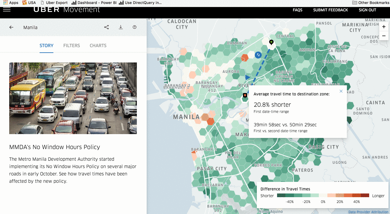
The Uber team has done an excellent job of using visualization and interactivity to make this data easily accessible to the general public. They’ve divided Metro Manila into hexagonal “zones” in which pick-up and drop-off points can fall. A user can view average travel times between any two zones, either by searching specific destinations, or by clicking the zones on the map. Users can compare how travel times vary between routes, times of day, and days of week.
Currently, when government officials try to quantify the traffic problem, their talking points are often limited to single data points: travel times recorded along specific roads, at specific times. In reality, travel times vary wildly from day to day, hour to hour, and route to route. Someone travelling from Caloocan to BGC on a Sunday morning, for example, will have a very different travel experience than someone travelling from Mandaluyong to Bicutan on a Friday evening. Data from services like Uber (and Waze and Grab), which are used by thousands of travellers and commuters, offer a much more intricate–and hopefully more accurate– picture of the situation on Manila’s streets.
We hope that transport planners will look into using Uber Movement to help evaluate the impact of traffic policies. For example, the tool visually shows the increase or decrease in travel times during the few weeks before and after October 12, 2016, the day the MMDA began implementing a new policy banning certain vehicles from select major roads between 7AM and 7PM. Previously, they’d been allowed to use these roads during “window hours” between 10AM and 3PM.
The tool has some limitations, of course. The key limitation is that this data only covers private Uber vehicles, which over-represent the AB demographic. Not all zones in Metro Manila are available, and some origin-destination pairs aren’t travelled frequently enough by Uber riders for the platform to generate adequate averages. The tool can’t tell you what specific routes Uber riders took to get from one zone to another. People who take public transportation like buses, the MRT, jeepneys, and tricycles are left out of the picture. Yet for these limitations, the tool offers us a much more varied and complex picture of travel times across the metro.